
Alex Luna • February 9th, 2026.
Floods are becoming more severe, frequent, and damaging. The global cost of flooding between 2020 and 2024 doubled compared to 2000-2004. These accelerating flood risks are having disproportionate impacts across the global agricultural value chain.
In 2025, floods in South Asia caused rice yields to plummet, and in 2022, floods in Australia led to a 300% increase in lettuce prices. The story is the same in most geographies: more frequent, severe, and unpredictable rainfall is driving flood risks in agriculture.
In this post, we will show how leading companies across the agricultural value chain are reducing losses and building resilience by using predictive modelling that provides warnings months in advance rather than days.
Floods are the second-most-costly natural disaster after storms. Recent research indicates that floods are becoming more frequent and increasingly concentrated during peak planting and harvest periods, increasing operational and yield risks for producers.
Here is how flood risks are impacting producers and others in the agricultural value chain:
Today, producers are rarely prepared for the floods they face. They lack the early-warning systems needed to make decisions with sufficient lead time. Current forecasts can’t tell producers exactly how a flood will impact their specific crop, how severe it will be, and exactly where it will occur.
There are four main reasons traditional flood forecasts lack decision-useful information:
Leaders across the agricultural value chain are mitigating these flood risks by using tools that provide decision-useful insights.
These tools are different from more traditional methods of flood prediction models:
See how probabilistic forecasts and crop-specific thresholds support earlier, more confident decisions.
Flood forecasting becomes most valuable when it helps decision-makers answer more questions than just, “Will it flood this year?”
To answer more in-depth questions, like: When should harvesting equipment or labor be moved? Which transport routes are most exposed? And when should contingency plans or insurance decisions be activated? ClimateAi combines three complementary perspectives into a single operational briefing, which goes beyond the historical record and river flow monitoring of typical flood monitoring. We use:
To demonstrate this in practice, we analyzed Orange Walk, Belize, the country’s largest sugar-producing region, where the northern sugar mill supports the livelihoods of around 40,000 people. ClimateAi models both major flood types affecting the region: flash floods driven by intense rainfall and river floods caused by rising river levels. These insights are available through daily 16-day forecasts and seasonal outlooks up to six months ahead.
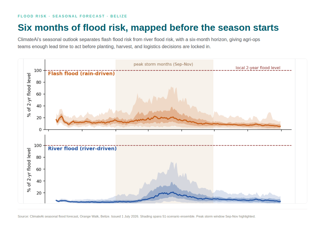
For the 2026 season, the model identified an important nuance that traditional forecasts could have missed. While the overall wet season was expected to be drier than average and a quieter Atlantic hurricane season is expected, October still emerged as the highest-risk month for flooding. This means producers could confidently plan for lower early-season flood risk while maintaining contingency plans for harvest and transportation later in the season.
The types of questions key stakeholders can answer with these flood insights allow for much better decision-making. For each of the region stakeholders, this is what that means in practice:
Historically, static flood risk maps have been sufficient for making general decisions. But as the frequency and severity of floods increase, the limitations of these maps are becoming clear. Producers need more accurate and dynamic forecasts tailored to specific crops.
ClimateAi offers structured, practical, and ROI-oriented models to support data-driven decision-making at every stage of production and across the value chain.
|
Decision Area |
How ClimateAi Helps |
|
Planting |
Avoid costly replanting with accurate forecasts of when the first rains of the season will be and whether they will lead to waterlogged or flooded fields. |
|
Harvest |
Time labor and machinery access before a flood kicks in, know what’s happening at the field level to make precision harvest decisions. |
|
Logistics |
Accurately anticipate riverway and road closures to avoid costly transport disruptions, and find alternate routes that avoid flood zones. |
|
Insurance |
Decide when coverage is worth the cost, and work with the insurer to enable parametric insurance. |
|
Investment |
Screen assets, commodities, and land for short-term flood risks and long-term increases in exposure. |
Floods are becoming more severe, frequent, and difficult to predict. As one of the most damaging climate risks in agriculture, knowing how they will impact your crop and when can be the difference between a good and a bad yield.
New models, like ClimateAi’s, are enabling producers to know how likely it is that a particular event will occur in specific fields way in advance, and how those floods will affect the specific crop they grow.
Crops with narrow planting or harvest windows and low tolerance to waterlogging, such as berries, potatoes, corn seed, and vegetables, face the highest risk.
Yes. Both flood frequency and intensity are increasing, and floods are occurring outside historical seasonal patterns and regions.
With modern climate intelligence, producers can probabilistically assess flood risk with 1-6-month lead times and even decades ahead for adaptation planning.
Fluvial, or riverine, flooding builds over time from upstream rainfall, while pluvial flooding is driven by heavy local rain that overwhelms drainage systems and occurs with little warning. Each requires different planning responses.