Upcoming Webinar 5/8 9:30am PT- Brewing Resilience: Hops, Barley, & Climate IntelligenceRegister Now

Why Our Forecasts are More Precise and Actionable
We do not have a crystal ball, nor are we aiming to tell you if you’ll have good beach weather on your vacation next month. Our models are designed to provide businesses and governments with the information to make confident, informed decisions about how to mitigate risks and take advantage of opportunities associated with climate and weather.
We work closely with our customers to ensure that our models are fit for their specific needs and priorities. With six patents, our solution offers enhanced customizability, granularity, accuracy, and actionability over publicly available and out-of-the-box tools.
And for high-impact events, we want to ensure you are getting the insights you need. That’s why we also offer an in-house meteorology team that leverages our data and platform to interpret these events and translate the impact to your business.
ClimateAi’s data science team evaluates our models constantly to ensure that they are effective and adding value for our clients. We use an array of metrics to evaluate several performance characteristics of our models, including:
The ability to accurately predict the directionality of climate and weather conditions (e.g. accurately forecast above, below, or near-normal categorical conditions)
The ability of our models to reduce the error of the mean forecast (e.g. the root mean squared error)
The relative performance of our probabilistic forecasts (e.g. the continuous ranked probability score, which is a generalization of the mean absolute error for probabilistic forecasts).
Transparency around the skill of our models is critical to building trust with our clients, and we are committed to providing clear explanations of those models and the methods we use to develop them. We provide clients with access to performance measures of our models through a process called “hindcasting.”
Hindcasting, also known as retrospective forecasting, is a technique used in weather and climate forecasting to test the accuracy of a model by applying it to past weather and climate events. This technique allows forecasters to test the model’s accuracy and compare its predictions to the actual weather conditions that occurred in the past. In addition to aiding in our own developmental benchmarking, these hindcasts help our customers understand the value-add of our forecasts for their specific use case.
In this short video, Dave explains how ClimateAi's models performed when forecasting Heat and Low Precipitation for Mato Grasso.
In this short video, Dave explains how using personal weather stations can help to downscale probabilistic forecasts and the improvements we've seen in working with our partners' weather stations.

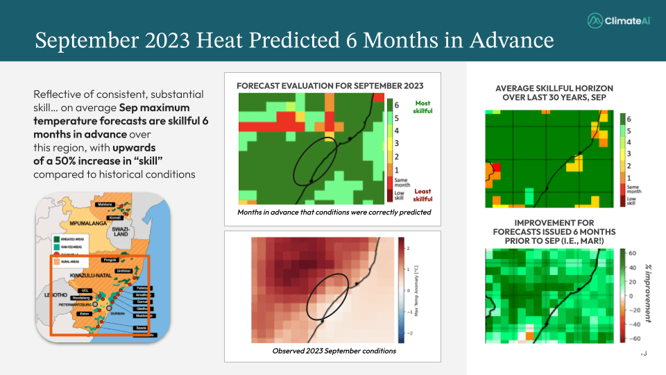
ClimateAi's heat forecast showed the impending heat event weeks ahead - better than any weather forecast. Our 6-month outlooks have shown to be 50-60% more accurate than historical data.
There are many public tools available, as well as competing vendor solutions, and it can be difficult to sort through the best one for your business needs. Existing short-term models often do not go beyond two weeks, while long-term models tend to be too broad to enable confident decision-making. ClimateAi’s ClimateLens platform was built to do just that–empower business leaders with insights that are precise and actionable.
| Time Scale | The ClimateAi Advantage | Why it Matters |
|---|---|---|
|
Seasonal (1 day - 6 months) |
Our probabilistic forecasts leverage dynamical models, observational and reanalysis products, and state-of-the-art data science techniques. We continuously evaluate the performance of our models and evaluate multiple observational and reanalysis data streams to ensure that the inputs to our models are of a high quality. For many applications, we integrate novel data points (e.g. oceanic temperatures and atmospheric pressure patterns), via advanced AI/ML techniques, to offer skillful forecasts for specific use cases (e.g. seasonal hurricane activity and extreme wind risks over coastal regions.) We move beyond the standard variables like temperature and precipitation and offer forecasts of business-specific variables like water reservoir levels, growing degree days, and date of first and last frost. |
Better Actionability Clear and transparent presentation and communication of a) our model’s skill (via hindcasting), b) the uncertainty of a given forecast, and c) business relevant metrics allows users to understand confidence levels for their variable of interest and confidently take actions accordingly. |
|
Future-looking under climate change scenarios (10+ years) |
We consider model quality at a local scale in order to provide optimal projections at a 25 km resolution, combining the best models for each possible location and variable (e.g. temperature, precipitation), using state-of-the-art data science techniques. Our probabilistic forecasts enable dynamic impact analyses, clear understanding of level of confidence, and multiple scenarios (worst/best case), etc. We can forecast business-specific variables like water availability, extreme weather metrics, or growing degree days. |
More Accurate Results Simply downscaling available models will only localize an inaccurate result. To truly have confidence in your outputs, you need to select the best models and, where necessary, correct their systematic biases. |
| ClimateAi has the capability to leverage satellite retrievals and on-the-ground sensors to localize to 10 km x 10 km (or even to a specific point). |
More Precision There can be great weather and climate variability within the same area–ClimateAi’s models can capture that variability and provide actionable insights. |
We are happy to walk you through our platform and methodologies on a quick call.