On-Demand webinar · ENSO 2026 Decoded → Watch The Recording
Alex Luna • March 20th, 2024.
A complex wine is said to have many different types of aromas and flavors and several layers of depth. This type of complexity could also be used to describe the climate wine growers find themselves heading into 2024 and beyond.
The top four wine grape growing regions in the world are Italy, France, Spain, and the United States. In 2023, climate volatility significantly affected the global harvest, with production projected to be its lowest in 60 years. Italy had an excessive rainfall that caused an abundance of downy mildew, destroying so much of its crop that it fell from the #1 position for wine production in the world to #2 behind France. The only region of the top 4 wine producing countries that had an increase in wine production in 2023 was California.
California produces many of the most popular types of wine, like Chardonnay, Cabernet Sauvignon, Pinot Noir and Pinot Grigio, to name a few.
California is a state with many different types of climate zones. Most of California’s vineyards are located close to the coast in what is known as a Mediterranean climate. This type of climate involves cool, humid breezes off the Pacific Ocean with fog and low clouds common in the morning then clearing an hour or so after sunrise, allowing the grapes the much needed 7-8 hours of sunlight. Typically, low clouds and fog conditions occur from spring and are not as common by summer.
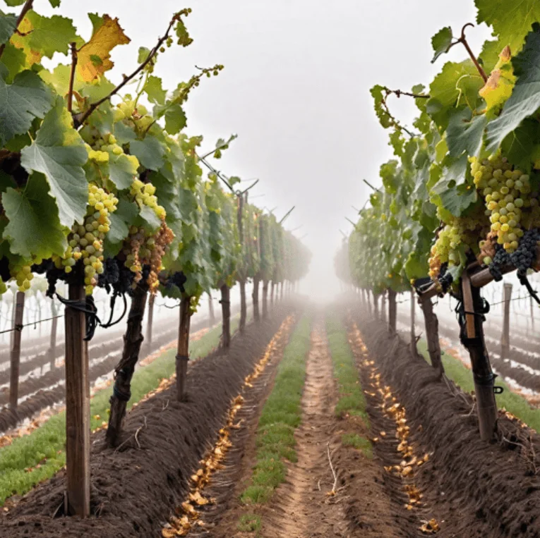 AI generated picture of a vineyard in fog.
In a normal year, the rainy season runs from the end of October through March before tapering off in April. April through October is mostly dry, with temperatures between 77F(25C) to 90F(32C). These conditions are optimal for the growth of grapes. However, most years from start to finish do not behave the same way.
This year is no different as the global weather pattern, El Niño, has been running the show and will be transitioning to a La Niña this summer. While El Niño patterns can lead to above normal winter precipitation in California, this year has been a toss-up. There have been a few periods of heavy rainfall from atmospheric river events sandwiched between weeks of dry conditions. One more heavy rain event is possible statewide the last week of March, but conditions are likely to dry out right on time at the start of April.
As El Niño winds down and La Niña develops, the focus will shift to the threat of drought and wildfires. La Niña tends to be a dry pattern for California overall. 2023 saw drought-crushing above normal precipitation and the wet trend continued into this winter. Even with the precipitation, the state is prone to rapid drying, heat waves, drought, and wildfires in the summer and fall. In 2010 and 2016, after a similarly wet winter, wildfires developed in June in the southern half of California. This is very similar to how 2024 has started.
By August, temperatures generally start to peak and the weather pattern will start to shift from a dominating area of high pressure (think dry and clear skies) to a pattern that sees storm systems pass just north of California. While this may seem good, it turns out these types of weather systems bring dry and windy conditions that can then lead to heatwaves as they pass by to the east.
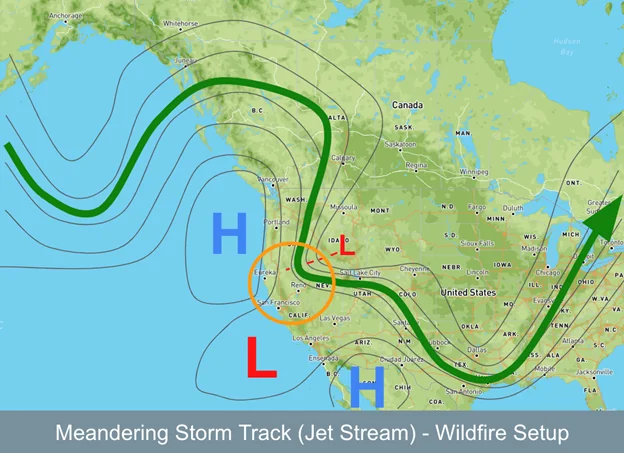 This pattern is quite common in the western US, but can lead to high winds,
very low humidity, and heat near the coast, all of which are good for wildfires.
Low humidity dries out vegetation.
During very dry years, this pattern is what leads to rapidly expanding wildfires. However, because 2023 and 2024 had fairly wet winters, the threat for major fires is lower this fall than years like 2020. The one area that may see a little bit higher risk will be Paso Robles as it is in an area that received less rain this winter than regions to the north. By June and July, the southern half of California may have enough dry grasses and shrubs to be the fuel source for wildfires. The bad thing about having a semi-wet winter is the low vegetation grows very quickly in the spring, but then dries out quickly and becomes a risk to burn by the fall.
Even if fires start and they don’t actually reach the vineyard, the smoke can do a lot of damage. A surface phenomenon called smoke taint can ruin wine during the winemaking process. If grape skins make too much contact with the juice, it can leave wines tasting like a wet ashtray.
Winemakers know it is very difficult to modify the process in mitigating smoke taint. Methods used by winemakers include washing the grapes on the vine/relying on rain to do so, changing fermentation techniques, and pressing the grapes more gently or in whole clusters.
Wines like Cabernet are often completely destroyed by smoke taint, but wines like Pinot Noir and Chardonnay are better suited for mitigation in this instance. Generally, it is easier to mitigate smoke taint with white wines than with red wines, due to the skins requiring less contact with the juice.
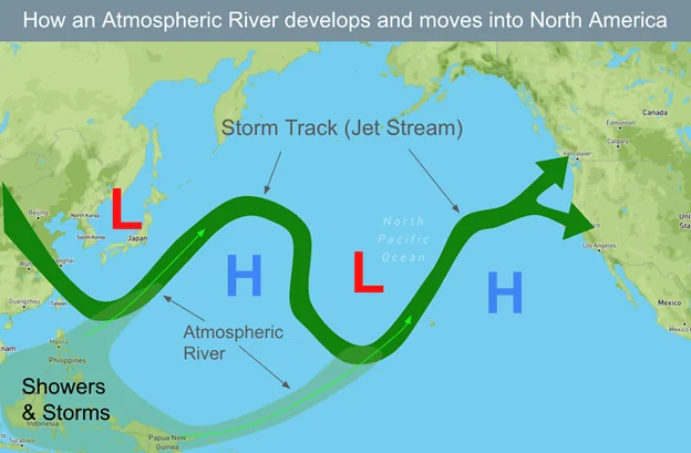
La Niña winters overall tend to be dry with below normal rain and snow as the storm track pushes wet weather north into the Pacific Northwest. However, due in part to global warming that has led to warmer ocean temperatures and other active global weather patterns, there will continue to be a higher than normal chance for atmospheric rivers. The main question then will be whether the plume of tropical moisture moves into Washington/British Columbia or California.
Atmospheric rivers are plumes of moisture that begin in
Indonesia or in the western Pacific Ocean near the equator. As a storm (L)
moves by to the north it picks up the moisture and feeds it along the
jet stream or storm track into areas from California to Canada.
La Niña favors areas north of California, which is why California
is drier during La Niña.
If we look at previous years where El Niño transitioned back to La Niña during the year, and the first La Niña winter which would be the 2024-2025, we would see that several winters like this one had above normal rain and snow at some point in the winter. While it doesn’t guarantee that the winter precipitation will be plentiful, it does offer some hope that another major, years-long drought like in 2012-2017 and 2020-2023 is not on the horizon, yet.
Grapes thrive on long days of sunlight and don’t need copious amounts of rain from day to day, but they do need some water. A move from the wetter El Niño pattern to a drier La Niña is not necessarily welcome news in an area that has been over irrigated and where groundwater has been mostly depleted during recent periods of intense drought. As history has shown us, first-year La Niña winters can bring much needed rain, often in short-duration chunks, between November and March. It is up to us to figure out how to capture the water when it falls to use later when it’s most needed. A long term method to capitalize on the rain that falls is to use a French practice called dry farming, where vines are carefully planted and positioned in a way that they only need to be watered once a season, or not at all.
As the smallest changes in microclimate can affect an entire harvest, using climate intelligence can help farmers to get ahead of climate volatility. Contact our team to find out more.